


- 11 mar 2025
- 4 min de lectura

Hello, adventurer!
Welcome to the post about Canada map created by Santiago Reyes. In this entry, you will see the different stages of creation and development of the illustration.
Final Illustration
To better organize the information from the development notes, the following topics were prioritized:
🌎✨ New Details
📝⚙️ Improvements
🌎✨ New Details
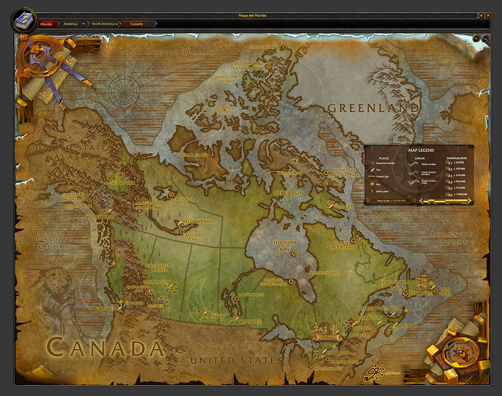
The main mountain ranges of Canada have been graphed: Winston Churchill Range, Canadian Rockies, Bow Rages and more within the Pacific Cordilleras.
The main water sources of the country have been added
Architectural landmarks have been added:
Ottawa: Parliament of Canada and National Gallery of Canada (repurposed)
Toronto: CN Tower
Saint Johns: Cabot Tower
Vancouver: Totem Poles (repurposed)
Secondary cities have been added:
Vancouver
Montreal
Calgary
Natural landmarks have been added:
Yukón: Mount Logan y San Elias Montains, Ni'iinlii Njik
Manitoba: Lake Winnipeg, Lake Manitoba, etc.
Nunavut: Parque Nacional Auyuittuq, Parque nacional Quttinirpaaq
Northwest Territories: Nááts'ihch'oh National Park Reserve, Great Bear Lake and Great Slave Lake.
Alberta: Banff National Park
Columbia Britanica, Alberta: The Canadian Rockies
Newfoundland and Labrador: Torngat Mountains
Ontario: Polar Bear Provincial Park y Niagara Falls
Extra POI (Point of Interest) have been added:
Nunavut, Manitoba, Ontario, Quebec: Hudson Bay
Nunavut: Foxe Basin, Queen Elizabeth Islands, Sverdrup Islands, Baffin Island and Belcher Islands.
Northwest Territories: Victoria Island.
The extreme points of Canada have been added:
North: Cape Columbia
South: Middle Island
East: St. Elias Mountains (St. Elias National Park)
West: Cape Spear
The country's main ports have been added
The North American Beaver has been added as the national animal.
The Cartographic Interface has been added.
The section related to this point is the Cartographic Interface. For this publication, which is in English so that the native population of this country can understand it, I’ll provide you with a quick summary of its purpose and the approach it uses to blend information with WoW art:
"The interface allows users to explore the maps dynamically, accessing detailed information about each area, its inhabitants, resources, and events. Additionally, the interface offers the option to customize the maps with preferences for cartographic information, displaying data related to demographics, geography, and key points of interest.
Conventions Table: The "Conventions Table" is a tool that allows users to view and modify the symbols and colors used to represent various geographic, political, and cultural elements on the maps.
Parallels: "Parallels" represent the geographic distribution of countries and regions in a map styled after World of Warcraft.
Scales: Map scales are tools that adjust the level of detail and extent of a map. This feature is highly useful for the cartographic interface. During the initial development of map scales, two types were proposed:
Graphic Scale: The graphic scale is an essential element for interpreting map information accurately. It consists of a segmented line that represents the relationship between real-world distances and the distances shown on the map. The graphic scale allows users to measure distances between points of interest on the map, as well as calculate the area or perimeter of represented regions. The graphic scale adjusts to the map's zoom level, ensuring it always displays the correct proportion between the map and reality. It shows distances in inches and miles (for the United States, which uses the Imperial System) and is located within the conventions table (or, in exceptional cases, outside of it).
Numerical Scale: The numerical scale expresses the relationship between distance on the map and actual distance on the ground. For example, a scale of 1:100,000 means that every centimeter on the map equals one mile in reality. The numerical scale is crucial for interpreting maps accurately, as it helps to understand the size and shape of territories, as well as the distance between them and points of interest.
Legends: Legends are essential elements for understanding maps. They allow users to identify the symbols, colors, and scales that represent various geographic, historical, and cultural aspects of a region.
Demographic Legend: The geographic function of maps goes beyond legends and symbols; it also reflects a reality: how many people live in a specific place. This feature applies only to major urban areas and facilitates the organization of illustrations for each country."
📝⚙️ Improvements
This is the first map with a new canva. Within this canva the following components have been restructured:
Corrections have been applied to the 4 existing molds: normal size and extended size.
The main canvas has been restructured to match the current coloring style for Dragonflight and The War Within world maps.
Fixed bugs on the edges where double and overlapping images could be seen.
Water edges have been fixed to not collide with the edges of the map artwork.
The nautical lines have been improved, bringing them more in line with the style of the world maps from Dragonflight and The War Within.
The cold embroidery characteristic of maps related to cold places has been redone.
BETA: A new technique is being tested for mountains, which have had their opacity reduced to be less invasive in the coloring of the map.
🗺️🤔 Credits
Blizzard Entertainment as the owner of World of Warcraft (WoW) and its art.
Stryxin - Forgotten Adventures (forgotten-adventures.net) as the initial creator of the map tutorial.
This concludes the development journey of the map. I hope you enjoyed it!
If you want to purchase the illustration and support the artist, you can visit the Buy section on the website or click the following button:
¡Together we are America!

Santiago Reyes
Project America Leader - World of Warcraft style maps
🚨©️ - Creative Commons (CC) 4.0
This work is licensed under a Creative Commons Attribution-ShareAlike 4.0 International License.


Comentarios